


Beschreibung
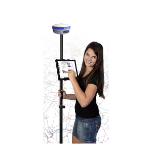
Stonex GNSS High Performer Base - Rover Set
If you don't have access to local correction services in the field or don't have an internet connection to receive correction data then the Stonex GNSS High Performer Base – Rover Set is the right choice for you.
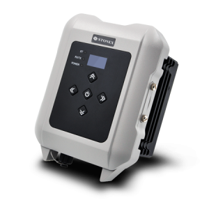
The base station behaves like a remote base station that you can set up to receive RTCM correction data. This is sent to the rover receiver via UHF radio. Most GPS receivers have internal radio modems ranging from 0.5W to 5W. For higher performance, an external radio such as the Stonex SR35 radio recommended. The rover is used as usual for your surveying tasks.
With the cube-a software you can operate the rover and the base.
Software:
Cube-a is a professional surveying software from Stonex, which was designed and developed for the Android platform.
Through the flexibility of the Android environment, Stonex has managed to create a simple and intuitive user interface that greatly supports surveyors in their daily work, saving time and increasing productivity.
Cube-a is available in three versions:
- Cube-a for GNSS
- Cube-a for GNSS+GIS and
- Cube-a for manual and robotic total stations
Cube-a is compatible with all Stonex GNSS receivers and supports rover, rover stop&go, base and static modes. Various views provide useful information on the status of the GNSS receiver, including the position and signal quality of the Atlas satellite.
MEASUREMENT
A simple and intuitive survey interface with helpful indicators gives the surveyor instant information about the survey conditions. On the screen you can view various information such as position accuracy, battery level, RTK correction delays and more. Intuitive displays allow you to easily change settings, view collected points, add new CAD elements and drawings, or continue surveying.
PHOTO & SKETCH
You can also use Photo & Sketch to enhance and complete the survey and stakeout functions. This function can be used during the survey or even at the points already recorded: take photos and add notes, add marker arrows or simple hand-drawn sketches and position them.
MARK OUT
In order to facilitate work in the field, all commands to start stakeout are grouped in one compact user interface. In order to make it easier for the surveyor to find the target point, the representation is made with both graphic and analytical functions.
Even on small monitors, the information and commands are always clearly arranged and legible, the buttons can be clicked without any problems and can sometimes be reduced in size to leave more space for the map.
INTEGRATED CAD
Cube-a includes an intelligent and easy-to-use CAD function. Designed to work with touch displays, the CAD allows you to easily draw points and other CAD elements with a smart pointer that can be moved with a finger.
Using object snaps such as point, midpoint, endpoint, intersection and others, it is possible to integrate surveying with new elements directly in the field.
TOTALSTATION
Cube-a is designed to fully support mixed survey work. A Cube-a survey supports GPS points and classic total stations and measures simultaneously. Cube-a supports all Stonex total stations via Bluetooth.
Scope of delivery:
- STONEX S980 A
- STONEX S850A
- Tablet Stonex UT56
- Tablet holder
- 2m GNSS rod carbon
- cube-a 5.x software
- Aluminum tripod
- Adjustment plate with adapter
- 25 cm extension rod
- UHF antennas
Optionally bookable:
- Online training via video conference
- On-site training at your premises