
The LD2 GIS (line documentation system) is completely developed by us and does not require any basic third-party software.
It's closed 100% compatible with all LD2 components and is not only used by Water associations, Municipalities / Municipalities or from Broadband company used.
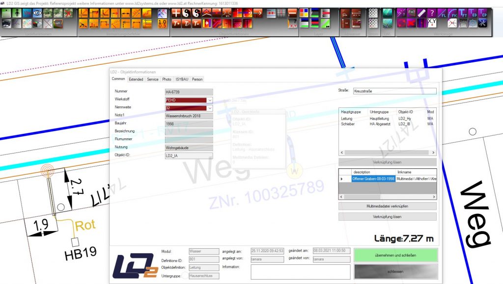
Our customers appreciate the ease of use and the quick understanding, even for GIS beginners.
We tried to combine the advantages of the ESRI world (the performance and the shape format) with the detail-loving display options of AutoCAD.
Very large projects can be completely displayed within 30 seconds and less
The GIS has few but highly compressed commands. With these, a company can cover almost all sectors.

If electricity, sewage, water, gas, Street lighting, District heating, optical fiber and much more. The system is arbitrary with a few clicks of the mouse expandable.
The Enrollment usually takes 3 days and can be carried out on site or via remote maintenance.
Construction, object statistics, plan information, attribute data maintenance are extremely easy to accomplish. The fully compatible field service solutions such as surveying and maintenance management, even smartphone apps, make the LD2 one extremely inexpensive and mighty Tool.
So why not replace an expensive, impractical system with a new, modern and inexpensive system with many additional options?
Just ask us without obligation. We would be happy to come to you and show you the system live how reliable and practical it works.
If you are interested, we are happy to provide one ROADSHOW make in your place. In this way, several interested companies in your area can get an idea of modern and innovative GIS software. We organize and invite. You just have to report that you have a no obligation ROADSHOW want to have organized.

General
Do you have a GIS and is it also suitable for the display and data comparison of line data? Or do you only have a WebGIS and the data in the data center? Oh dear.
Fortunately, you can be helped! Get the data back into your home. Even that, as you may find out, can be a problem for some data centers.
Make sure that your data doesn't end up in a data graveyard for a lot of money!
Because the The data is with YOU and not with us. You are always the master of the data.
Having one and the same tool for the water master, mayor and construction officer is probably not a bad compromise.
- Trades (modules, specialist models) can be expanded free of charge (electricity, water, waste water, gas ...)
- Small functionality with a big impact. This means a very short training period (usually 3 days for GIS)
- Ease of use, even for GIS beginners
- Due to the possibility of bidirectional data flow back and forth between surveying - GIS and maintenance management with a fingertip on the touchscreen, we are certainly unrivaled at the moment. The price-performance ratio is currently also unrivaled.
- The biggest advantage, however, is that you no longer have to trace the thousands of surveying dumplings (as with other solutions) because the survey in nature draws in the GIS. The data is post-processing-free! That is what makes the big savings.
The LD2 GIS is based on a small server system as a database and thus PostgreSQL is used. The LD2 GIS does not use any other third-party products.
When the graphical user interface is started, all data from the database is loaded into the RAM memory and then the whole supply area shown on the screen at once.
As a rule, a supply area with approx. 900 km² needs far less than a minute to be completely displayed on the screen. During the working session, all you need to do is navigate the plan. Thus result extremely short response times; This enables fast and fluid work.
The license model currently covers four options:
- Full license - All modules and all object definitions can be edited on this workstation
- Time license model - You can rent the workplace for tasks for a certain period of time, e.g. for summer interns
- Property type license model - You can use a fully-fledged GIS workstation, but this can only be edited for one type of object and made available to your employees
For example, employees are only allowed to work on the street lights but not on the water network. - Floating license - pool license
You install as much LD2 GIS on your computers as you want and there is a pool of licenses. For example, you buy 3 pool licenses, ie a maximum of 3 PCs can dial into the GIS, the 4th receives a message when it starts that it has to wait until the pool is released again.
The LD2 GIS supports this Data flow management, this means that decentralized work is possible and that data is produced in two different locations with a 3.5-bit internet connection using the data flow management. The data is automatically compared in real time and every minute.

The performance
Our GIS system stands out from other systems from other providers due to its enormous speed and ease of use.
The availability of object definitions and freely definable modules, the system can be adapted to your company within a very short time. As a result, changes in operational processes or new requirements can be implemented quickly, quickly, easily and free of charge with the LD2 GIS. These individual Adjustments also flow contactless with the data comparison directly to the LD2 measurement solution and can also be used immediately in the field or develop their effects.
communication
The LD2 line documentation system is ideally suited not only for the documentation of line networks but also for tasks that go far beyond this.
As examples: cemetery management, tree cadastre, green space cadastre, playgrounds, play equipment management, asphalt management, management of asphalt damage, drainage area determination and administration, easement management, lease management and much more
Data flow management
A completely new module, the so-called data flow management or data flow management, gives the customer the opportunity to work simultaneously at several locations that are not connected to one another in the network, on one and the same project, and to generate or modify data. The data flow management ensures that all changed data can be compared independently in real time and without the intervention of the employee via a mediocre to poor internet connection. Decentralized work, asynchronously across several countries, on one and the same GIS project is very easy.
As we know, in many cases the situation is such that the building yard is not connected to the town hall and thus the internet connection between these two points is either very expensive or has poor bandwidth. In most cases, collaboration is therefore only possible via a so-called GIS viewer, which is not a serious vector graphic, offers no performance and is not usually equipped with the technical interfaces that are required at the building yard to carry out their daily work to be able to.
With so-called data flow management each location has its own GIS database and data flow management takes care of the central administration of the setting and the automatic comparison of objects across these locations fully automatic. Basic settings on the project can only be set at location 1; these settings flow fully automatically from one database to another each time the LD2 software is started in other locations.
The data flow management is working fully automatic every minute, semi-transparent in the background and gives both acoustic and visual signals so that employees are always indirectly informed whether the data flow management is working correctly. Data flow management can at any time for a specific GIS project or can be switched on or off for all ongoing GIS projects at the respective locations.
Interfaces
In our system there are many program modules and interfaces between which the LD2 can communicate without any problems.
- DWG Imort
- DXF import & DXF export
- Shape import & shape export
- ALKIS NAS interface import
- ISYBAU master data import
- ISYBAU master data export
- ISYBAU valuation data import
- ASCII / CSV import & CSV export
- Google Earth export
- VGA consumption data import
- Owner import (Austria for DKM)
- …
Examples
Area of application tree register
- Creation of a digital tree register with all the necessary data
- Identification of the tree (e.g. with number)
- associated green area
- Genus / tree species
- Plant year / age (if known)
- Status (e.g. natural monument)
- Photo of the tree
- Risk assessment within the scope of the duty to maintain safety
- Responsibility, "owner" (municipality, district, private, etc.)
Area of application street lighting
- Convenient management and maintenance of the inventory data (e.g. type of luminaire, operating mode, street and location, information on the foundation, installation date, mounting height as well as factual data on light sources, connection cables, light body types, mast shapes and brackets, light point overhang, information on LED light sources)
- Any damage found can be displayed in the GIS. This means that the responsible clerk can easily keep track of upcoming repairs.
- Location-related archiving of test reports
calculation
All prices quoted relate to net prices, excluding VAT. and as of March 2021.
A GIS workstation costs from € 7500. With this you can one, two or many modules can be processed to achieve their full functionality.
However, interfaces are not included in this price. In order to be able to make the plan available to other employees in your company, we offer the option of a so-called Information desk.
With the exception of construction tools, this offers the complete range of functions of a workstation; View of Orthophotos, Ads all Modules and plants and the individual switching on and off of trades, printing functions, querying attribute data, etc.
This Information desk costs from 440 € per workstation.
Another option for the LD2 GIS is to use a LD2 pool license, which can be bought from us from 8200 €. If a GIS has already been purchased, the upgrade starts at € 795. With the pool license there is a pool of licenses. For example, 3 pool licenses have been purchased and all three GIS have started, so the 4th GIS user can only start the GIS when a license becomes free (when the program is closed).
The annual maintenance fees are calculated based on the software program modules you use.
The price is calculated from 20% of the list price of the respective program module. In the first year, the maintenance fees are calculated on a pro-rata basis until the end of the year. In this Maintenance contract it includes the repairs of all bugs you have discovered, the availability of ongoing online updates, the receipt of Information newsletter, where the permanent further development is sent to you and you will be informed as soon as new Updates be available.
Individual requirements, such as the installations on other workstations, servers, or configurations and special data imports or data manipulations can be made in the form of Services be booked with us. You have the option of a support check for this purpose.