
The LD2 GNSS surveying software is unique among its kind:
For RTK GNSS devices of many brands such as: Trimble, Stonex, Leica, Ashtech and many more. Not only can this solution show dimensions, no, you always have that ENTIRE PLANWERK with in the FIELD.
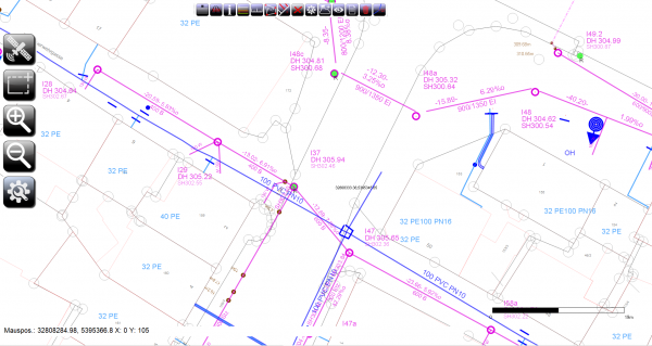
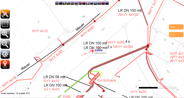
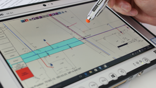
You can see measured lines and objects RIGHT AWAY RIGHT AWAY on the screen. You have the measurement with a fingertip on the touchscreen POST-PROCESSING-FREE in the LD2 GIS. No more pointless reworking of surveying dumplings by your service providers. Our customers claim (and we know it) that it is very easy to save the entire investment costs of a GNSS system FROM US within a day if you are willing to trust such a modern and easy-to-use system yourself Hand to take.
Plowed out landmarks are no longer a problem because the spot can be found again in a few seconds. Switch on and watch. That's all.
There's no need to type in dull coordinate pairs because you already have ALWAYS EVERYTHING in the field to have. And even with attribute data and in color.
You can also load your plans by street and house number. Even a true-to-scale printout directly from the measurement system is child's play for us. You have never seen anything like it. We are convinced that we currently have the best and most powerful surveying solution that is easy to use. So why shouldn't you benefit from it?
General
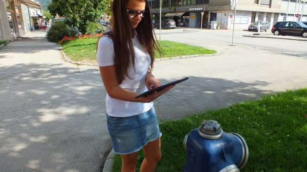
Would you like to secure the knowledge of your water master and bring the pipe network into the digital world?
The LD2 GNSS survey software is the only one that is so easy to use that anyone can use 5 minutes of training can generate a digital line network very easily and quickly.
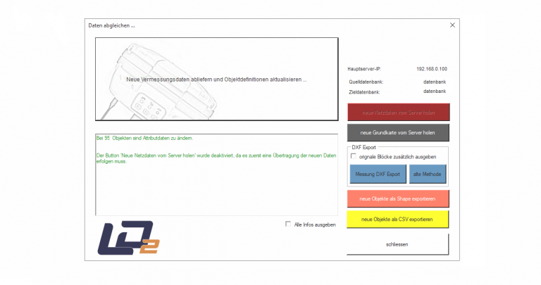
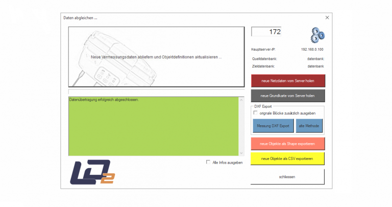
The contactless data comparison The LD2 GIS makes working in the field even easier. The advantage that there is the bidirectional overall data comparison and that ALL data is always on the tablet, LD2 saves you as the only provider the time-consuming going back and forth to copy small pieces of plan with the memory card into the measuring device. Furthermore, our LD2 GNSS surveying solution is the only one where you don't have to spend time with coded surveying points on the PC, because the plan already does no post-processing comes from the field.
To the procedure of the surveying software
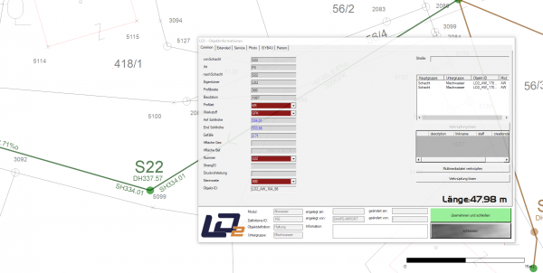
The objects that can be seen on the screen during real-time measurement can be in the form of Object definitions freely defined will. These object definitions can be created and modified for lines, symbol areas and double line objects. Because the software creates a full line plan can draw with symbols and polygons, including protective tubes and multimedia files, you save countless hours of post-processing over the course of the year.
Another advantage is that you no longer have to have expensive post-processing carried out by service providers. With this feature, the surveying solution finances itself within a few weeks.
The data synchronization
The LD2 GNSS surveying solution draws the finished line plan fully automatically in real time. The line plan is based on bidirectional data synchronization, which can take place contactlessly via WLAN with the central server, is transferred to the GIS with all data without postprocessing.
The data flow into the GIS, which can no longer be differentiated visually or technically between measured and manually drawn objects.
The attribute data can be entered in the field and photos can be taken, which are then linked to the objects fully automatically. The photos and multimedia files can also be called up immediately in the GIS.
Communication with third-party systems
The LD2 GNSS survey solution can also "Stand alone" can be used and the full scope of services can still be used. After the survey, even if you do not have the LD2 GIS systems, you can export the data directly on the tablet PC in the form of ASCII, Shape or DXF data and, if necessary, directly to the data receiver via the SIM card send.
The possibility of Self-defining from Object definitions, Object types, color settings, etc. remain fully available.
Areas of application
Our LD2 surveying software is currently being used for very many subject areas Used in practice, such as measuring water pipes, electricity, gas, street lighting, tree cadastre, asphalt damage, asphalt areas in general, asphalt area cadastre, green area cadastre, empty piping for fiber optic lines, communication, distribution cabinets, playgrounds, cemetery objects and much more.
You can thus:
a) all important objects in the field precisely positioned to capture
b) the Real-time plan let draw
c) these objects also at any time in the field find againsuch as restoring boundary points in the form of staking a boundary stone
Further areas of application are provided by you in the form of freely definable, free of charge Modules Are defined. You can expand object definitions for the system perfectly for your company.
calculation
You can get an LD2 RTK GNSS surveying solution from us from 1760 €.
Of course, we will come to you here personally and train you on our easy-to-learn surveying solution within a day.
With a service price of up to € 7.00 per running meter, the entire purchase has paid for itself within a few hours.
That sounds incredible, but we say: Test us, otherwise you won't believe it.
Not only that the solution can pay for itself within a few hours and that the data is immediately available, represent a major cost saving, but you also save yourself the pointless post-processing of the "measurement dumplings" by service providers or your own time, because our solution the line plan without postprocessing, draws in real time and fully automatically.