


Beschreibung
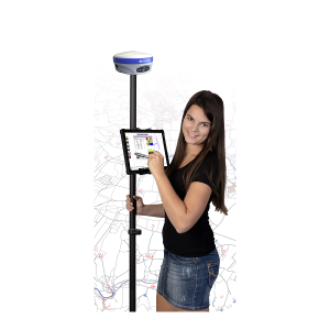
LD2 GNSS survey software – Surveying can be easy
Dreaming of a simple surveying solution? Our LD2 GNSS survey software works differently than other solutions. Our system is one mobile GIS/NIS, because you always have all object data on the tablet and therefore in view to have. The innovative software solution generates the data in the field and in real time as finished plan shown. Lannoying rework, more complex Data–export or copying are no longer necessary. You must, too no special preparations meet if you want to measure there all data already in the system are.
With the LD2 GNSS survey software you have the complete plan of your entire area with you in the field. Included all external documents such as descriptions of your systems as pdf files, lists of your spreadsheets or photos and videos. Of course, the basic map and line data/network data are also in the field. Thanks to our unique operating concept and the new GNSS receiver with inclination technology, you are extremely fast when collecting data in the field. You measure in the current plan and can check your work immediately.
Next is the LD2 GNSS survey software the only one in which you can already enter attribute data when measuring, Take pictures and can link. And all this, even though we no cloud solution to have. The data is yours and belongs to you.
How it works?
Whether water pipes, sewer, lighting, broadband, traffic signs, etc. - no matter what you measure, in our solution the pipe sections are immediately in the right color, the right application form and the built-in components represented with the correct symbols. So you can in the field with a push of a button select everything you want to see.
A line was laid in the protective tube? No problem! The protective tube is measured at the same time as the line. Would you like to create a tree register tomorrow? Also no problem! In five minutes you have created the industry model and the necessary objects for it. All without further costs. With us you can new application modules free of charge create.
Finding objects again is also a breeze. Regardless of whether you want to find boundary points in the base map or objects from the network data. With a click on an object, the LD2 measurement solution leads you to the objects you are looking for. Once you have found the property, you can immediately query the owner by clicking on the property number.
Of course you can import data and export data with the LD2 surveying solution. This means that we are open to all common GIS systems on the market and can accept and transfer data.
Scope of delivery:
- LD2 surveying software
- DXF import / export optionally also with shape import / export
- Online learning video
Optionally bookable:
- Data transfer of your GIS project status.
- Online training via video conference
- On-site training at your premises
- Maintenance contract
You can find a presentation video of the LD2 GNSS surveying solution on YouTube.